
 ATAY MÜHENDİSLİK
PHOTOGRAMMETRIC DATA PROCESSING SOFTWARE
UltraMap
From imagery to geospatial data.
UltraMap is a modular software suite that transforms UltraCam imagery into photogrammetric products. Manage the entire process in one application, from data input to orthophotos, point clouds, DSM/DTM and textured 3D models.
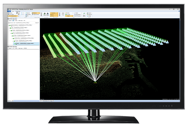
End-to-end workflow
Essentials, AT, Dense Matcher, Ortho Pipeline and 3D.
Diverse data outputs
Orthophotos, elevation models and textured 3D products.
One application
Processing, viewing, editing and quality control.
Distributed processing
Processing clusters configured to project needs.
Every production stage in the same environment.
UltraMap Studio combines data preparation, colour balancing, aerial triangulation and product generation in one project. Automatic processing is complemented by user edits and quality checks when needed.
Essentials
Calibration, radiometric processing and global colour balancing.
AT
Tie points, control points and bundle adjustment.
Dense Matcher
Generate DSMs, DTMs and point clouds through dense matching.
Ortho Pipeline
Orthorectification onto DSM/DTM and orthomosaic production.
3D
Textured TIN and three-dimensional point-cloud production.
Distributed processing
Manage workloads across multiple processing computers.

Manage image quality.
Essentials applies camera calibration to raw data and supports radiometric consistency between nadir and oblique images. Colour balancing, TPP and AMC prepare imagery for production.
- Joint balancing of nadir and oblique images
- User-editable radiometric settings
- Standard outputs such as TIFF, JPEG and GeoTIFF
Elevation, orthophoto and 3D production.
Dense-matching results feed elevation model and orthomosaic production. Refine results with heightfield and seamline edits; the 3D module provides textured models and various export options.
- DSM, DTM and point clouds
- Editable seamlines and blending areas
- Textured TIN and Cesium 3D Tiles outputs

Explore the details.
System information and configuration details for UltraMap.
Modules and output formats
| Essentials: imagery | TIFF (8/16 bit), JPEG, GeoTIFF, WorldFile |
|---|---|
| AT: exterior orientation | CSV, Bingo, PAT-B |
| Dense Matcher: DSM / DTM | GeoTIFF |
| Dense Matcher: point cloud | LAS |
| Ortho Pipeline: orthomosaic | GeoTIFF, WorldFile, Seamlines |
| Ortho Pipeline: colourised point cloud | LAS |
| 3D: textured model | OBJ, DAE, OSGB, Cesium 3D Tiles |
| 3D: point cloud | LAS RGBI, LAS CIR |
Outputs and functions depend on active licence modules, software version and project data. A WorldFile is a positioning file accompanying an image.
System and operation information
| Input | UltraCam nadir and oblique images |
|---|---|
| Main application | UltraMap Studio |
| Core modules | Essentials / AT / Dense Matcher / Ortho Pipeline / 3D |
| Orientation support | GNSS/IMU import and ground control points |
| Radiometric tools | Global colour balancing, TPP, AMC |
| Elevation editing | Heightfield Editor |
| Orthophoto editing | Seamline and blending-mask editing |
| Water surfaces | Water-mask and geometry-editing tools |
| Reprocessing | Local reprocessing and processing queue |
| Processing infrastructure | Distributed processing; optional GPU for relevant stages |
| Licence options | Subscription or perpetual licence |
| Quality control | Image, block and product quality-control tools |
Hardware, processing capacity, licence scope and version compatibility are assessed according to project size. This module and feature summary is based on the UltraMap version 6 manufacturer brochure and product page.
Manage your project step by step.
Prepare
Import raw images; complete calibration, colour and block preparation.
Check
Evaluate orientation, elevation and image quality with the relevant tools.
Deliver
Export required 2D and 3D products through licensed modules.
Solutions that work together.
UltraMap Brochure
View the manufacturer's English PDF brochure.
Choose the right system for your project.
Let us select UltraMap modules and processing capacity for your production goals.