
Matrice 300 RTK
Superior Performance.
DJI Matrice 300 RTK is an industrial drone inspired by modern aviation systems. It combines up to 55 minutes of flight, advanced AI capabilities and six-directional sensing and positioning in a flexible platform.
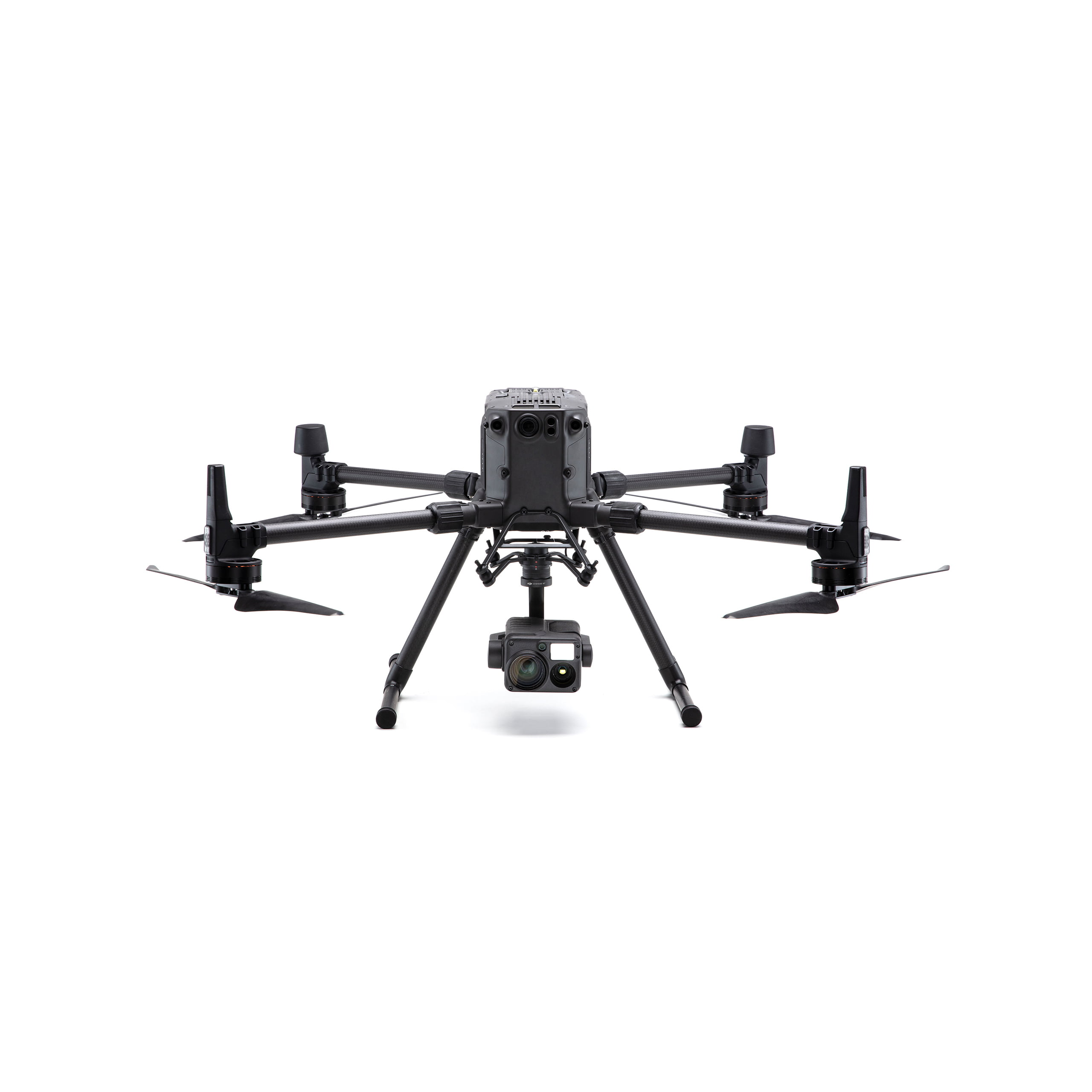
The payload configuration shown is an example.
Maximum Flight Time
Extended flight time without payload.
Total Payload
Configuration with up to three simultaneous payloads.
Ingress Protection Rating
Airframe suited to different field conditions.
Sensing and Positioning
Vision and infrared sensing systems.
OcuSync Enterprise
FCC / CE maximum transmission distance.
Operating Temperature
Operation across a wide temperature range.
Performance values apply under test conditions and vary with payload, battery, environment and regional standard.
FLIGHT PERFORMANCE
Enhanced Flight Performance
The improved aircraft and propulsion system support stable, efficient flight in challenging conditions. Foldable arms and removable landing gear simplify transport.

23 m/s
Maximum horizontal speed in S mode; flight performance for your missions.
12 m/s
Maximum wind resistance. Actual flight performance depends on payload and environment.
7000 m[3]
Maximum altitude above sea level with 2195 high-altitude propellers and takeoff weight ≤7 kg.
ENHANCED TRANSMISSION SYSTEM
OcuSync Enterprise
OcuSync Enterprise combines long-range connectivity, three-channel 1080p transmission and automatic real-time switching between 2.4 / 5.8 GHz bands.
Stable Connection
Frequency selection according to interference supports stable connectivity in complex field conditions.
15 km / 8 km[4]
Maximum transmission distance: 15 km under FCC, 8 km under CE.
AES-256
Video transmission encryption protects data between aircraft and controller.

MULTIPLE PAYLOAD CONFIGURATIONS
One Platform. Different Missions.
Matrice 300 RTK supports single downward, dual downward and single upward gimbal options. With suitable mounts, it can carry up to three payloads simultaneously. Maximum total payload is 2.7 kg.

Photogrammetry and LiDAR
Photogrammetry with Zenmuse P1; LiDAR collection with L1 or L2. L2 requires DJI RC Plus.
Multi-Sensor Imaging
H20 family and, with a compatible controller, H30 / H30T address different inspection and observation needs.
Lighting and Audio
Zenmuse S1 and V1 offer lighting and audio broadcasting on M300 RTK with DJI RC Plus.
The single gimbal damper limit is 930 g. The total 2.7 kg capacity does not apply separately to each connection. Payload, mount and controller compatibility must be assessed for the installation.[5]
INTELLIGENT LIVE MISSION RECORDING
Consistent Results on Repeated Missions.
Record mission steps including gimbal direction, aircraft movement, photo capture and zoom. Use these recordings to create automated routes for recurring inspections.
Live Mission Recording
Record your field flight steps to repeat the same inspection on later missions.
AI Spot-Check
Use AI-assisted target reframing with Zenmuse H20 Series.
PinPoint and Smart Track
Mark target locations or support moving-target tracking with compatible H20 / H20N payloads.
Mission Planning with DJI Pilot 2
Plan waypoint, mapping, oblique and linear flights. Mission types and intelligent features depend on sensor and software configuration.
FLIGHT TIME
Plan Flights for Your Mission.
Matrice 300 RTK flight duration varies with payload. The values below show example configurations from the manufacturer's chart on Atay's product page.
- Without payload
- 55 min
- With Zenmuse H20
- 45 min
- With Zenmuse H20T
- 43 min
- With maximum payload
- 31 min
Chart values apply under ideal test conditions and are not actual mission durations. Maximum payload is 2.7 kg. Battery condition, flight profile and environment affect flight time.[1]
SENSING AND SAFETY
Know Your Surroundings.
Six-Directional Sensing
Dual vision and infrared sensors provide six-directional obstacle sensing and positioning. Sensing depends on light and surface conditions.
Dedicated FPV Flight Camera
Monitor flight direction with a 145° FPV camera while the mission camera points elsewhere.
Redundant System Design
Redundant flight control and sensors work with the dual-battery system to support operational continuity.
Health Management System
Review system status, error logs, software versions and maintenance information in one place with HMS.
DJI AirSense
Supports operator awareness with information about nearby ADS-B-transmitting aircraft.
CSM Radar Support
Expand sensing with optional CSM Radar. Requires compatible software and connection configuration.
CONTROL AND POWER
A Continuous Field Workflow.
DJI Smart Controller Enterprise
A 5.5-inch, 1000-nit display; up to approximately 4.5 hours with internal battery and WB37. Dual-controller operation lets teams share aircraft and payload control.
DJI RC Plus Option
Upgrade to DJI RC Plus with compatible software. Zenmuse L2, H30 / H30T, S1 and V1 require RC Plus; XT2, XT S and Z30 are not supported with this controller.
Dual TB60 Battery System
Two TB60 batteries power extended field missions. Batteries can be changed without powering off while the aircraft is on the ground.
BS60 Intelligent Battery Station
Storage for 8 TB60 and 4 WB37 batteries; charges two TB60 and one WB37 simultaneously. With 220 V input, two TB60 batteries charge from 20% to 90% in about 30 minutes.
TECHNICAL SPECIFICATIONS
Every Detail, in One Place.
Expand the specifications for the aircraft, controller, sensing system and batteries.
Drone and Flight Performance
| Product Name | DJI Matrice 300 RTK |
|---|---|
| Dimensions | Unfolded, without propellers: 810 × 670 × 430 mm Folded, with propellers: 430 × 420 × 430 mm |
| Diagonal Wheelbase | 895 mm |
| Weight — With Single Downward Gimbal | Without batteries: approximately 3.6 kg With two TB60 batteries: approximately 6.3 kg |
| Maximum Takeoff Weight | 9 kg |
| Maximum Total Payload | 2.7 kg |
| Maximum Payload of Single Gimbal Damper | 930 g |
| Maximum Flight Time | 55 minutes; without payload. [1] |
| Flight Time with 700 g Payload | Forward flight: 45 minutes Hovering: 43 minutes Specified test values at sea level. [1] |
| Maximum Horizontal Speed | S mode: 23 m/s P mode: 17 m/s |
| Maximum Ascent Speed | S mode: 6 m/s P mode: 5 m/s |
| Maximum Vertical Descent Speed | S mode: 5 m/s P mode: 4 m/s |
| Maximum Tilted Descent Speed | S mode: 7 m/s |
| Maximum Angular Velocity | Pitch: 300°/s Yaw: 100°/s |
| Maximum Pitch Angle | 30° P mode with forward vision enabled: 25° |
| Maximum Altitude Above Sea Level | 2110 propellers: 5000 m; takeoff weight ≤7 kg 2195 high-altitude propellers: 7000 m; takeoff weight ≤7 kg [3] |
| Maximum Wind Resistance | 12 m/s |
| Ingress Protection Rating | IP45 [2] |
| Operating Temperature | -20 °C to +50 °C |
| Supported Gimbal Configurations | Single downward gimbal Dual downward gimbals Single upward gimbal Single downward + single upward gimbal Dual downward + single upward gimbal Mounts and payloads are assessed separately. [5] |
Positioning and Video Transmission
| GNSS | GPS + GLONASS + BeiDou + Galileo |
|---|---|
| Hovering Accuracy | Vertical: ±0.1 m (vision), ±0.5 m (GPS), ±0.1 m (RTK) Horizontal: ±0.3 m (vision), ±1.5 m (GPS), ±0.1 m (RTK) P mode; calm or light-wind conditions. |
| RTK Positioning Accuracy | With RTK enabled and FIX solution: Horizontal: 1 cm + 1 ppm Vertical: 1.5 cm + 1 ppm |
| Transmission System | OcuSync Enterprise |
| Operating Frequency | 2.400–2.4835 GHz 5.725–5.850 GHz Frequency availability varies by region. |
| Maximum Transmission Distance | FCC/NCC: 15 km CE/MIC/SRRC: 8 km In an unobstructed environment free of interference. [4] |
| Live View | Supports three-channel 1080p video transmission; image sources depend on the selected payload and controller configuration. |
| Encryption | AES-256 video transmission encryption |
| Aircraft Transmitter Power — EIRP | 2.4 GHz: 29.5 dBm (FCC); 18.5 dBm (CE/SRRC/MIC) 5.8 GHz: 28.5 dBm (FCC/SRRC); 12.5 dBm (CE) |
DJI Smart Controller Enterprise
| Display | 5.5-inch; 1920 × 1080 touchscreen; 1000-nit brightness |
|---|---|
| Transmission Frequency | 2.400–2.4835 GHz 5.725–5.850 GHz |
| Transmitter Power — EIRP | 2.4 GHz: 29.5 dBm (FCC); 18.5 dBm (CE/SRRC/MIC) 5.8 GHz: 28.5 dBm (FCC); 12.5 dBm (CE); 20.5 dBm (SRRC) |
| Internal Battery | 18650 Li-ion; 5000 mAh; 7.2 V |
| External Battery | WB37; 4920 mAh; 7.6 V; LiPo; 37.39 Wh |
| Operating Time | Approx. 2.5 hours with the internal battery Approx. 4.5 hours with the internal battery + WB37 |
| Internal Battery Charging Time | Approx. 2 hours 15 minutes with a 12 V / 2 A USB charger |
| WB37 Charging Time | With BS60: approx. 70 minutes at 15–45 °C Approx. 130 minutes at 0–15 °C |
| Rated Power | 17 W |
| USB-A Power Output | 5 V / 1.5 A |
| Storage | 32 GB internal storage; expandable with microSD |
| Video Output | HDMI |
| Operating Temperature | −20 °C to +40 °C |
| Alternative Controller | DJI RC Plus is supported with compatible aircraft firmware. Changing the controller affects payload compatibility. [5] |
Vision and Infrared Sensing System
| Sensing Directions | Forward, backward, left, right, upward and downward |
|---|---|
| Vision System Measurement Range | Forward / backward / left / right: 0.7–40 m Upward / downward: 0.6–30 m |
| Vision System Field of View | Forward / backward / downward: 65° horizontal, 50° vertical Left / right / upward: 75° horizontal, 60° vertical |
| Vision System Operating Environment | Surfaces with clear patterns and adequate lighting (>15 lux). |
| Infrared Measurement Range | 0.1–8 m |
| Infrared Field of View | 30° (±15°) |
| Infrared Operating Environment | Obstacles with large, diffusely reflective surfaces; reflectivity >10%. |
| Optional Sensing Accessory | DJI CSM Radar. Sold separately; compatible firmware and mounting are required. |
FPV Camera and Auxiliary Lights
| FPV Resolution | 960p |
|---|---|
| FPV Field of View | 145° |
| FPV Frame Rate | 30 fps |
| FPV Use | Provides a live view during flight; does not record photos or video. |
| Auxiliary Light Effective Distance | 5 m |
| Lighting Mode | 60 Hz, continuous illumination |
TB60 Intelligent Flight Battery
| Battery System | Two TB60 batteries; supports battery replacement without powering down while the aircraft is on the ground. |
|---|---|
| Capacity | 5935 mAh |
| Voltage | 52.8 V |
| Battery Type | LiPo 12S |
| Energy | 274 Wh |
| Net Weight — One Battery | Approx. 1.35 kg |
| Operating Temperature | -20 °C to +50 °C |
| Recommended Storage Temperature | +22 °C to +30 °C |
| Charging Temperature | Battery temperature: +5 °C to +40 °C. The BS60 automatically heats batteries before charging in colder environments. |
| Maximum Charging Power | 470 W |
| Charging Time — 220 V | Two TB60 batteries: approx. 60 minutes for a full charge Approx. 30 minutes from 20% to 90% |
| Charging Time — 110 V | Two TB60 batteries: approx. 70 minutes for a full charge Approx. 40 minutes from 20% to 90% |
| TB65 Alternative | The M300 RTK also supports TB65 batteries with compatible firmware and charging equipment. TB60 and TB65 specifications differ. [6] |
BS60 Intelligent Battery Station
| Dimensions | 501 × 403 × 252 mm |
|---|---|
| Net Weight | Approx. 8.37 kg |
| Battery Storage Capacity | 8 TB60 and 4 WB37 batteries |
| Simultaneous Charging | 2 TB60 and 1 WB37 battery; prioritises batteries with higher charge levels. |
| Input | 100–120 V or 220–240 V AC; 50–60 Hz |
| Maximum Input Power | 1070 W |
| Output Power | 750 W at 100–120 V input 992 W at 220–240 V input |
| Operating Temperature | −20 °C to +40 °C |
| TB65 Charging Compatibility | BS60 firmware must be v7 or later. BS65 supports TB60 and TB65 batteries. [6] |
Controller and Payload Compatibility
| P1 / L1 / H20 / H20T / H20N | Supported on the M300 RTK with both DJI Smart Controller Enterprise and DJI RC Plus; compatible firmware is required. |
|---|---|
| Zenmuse L2 | Requires DJI RC Plus on the M300 RTK. Only the single downward gimbal mount is supported. |
| Zenmuse H30 / H30T | Requires DJI RC Plus and current compatible firmware on the M300 RTK. |
| Zenmuse S1 / V1 | Requires DJI RC Plus and current compatible firmware on the M300 RTK. |
| Zenmuse XT2 / XT S / Z30 | Supported with M300 RTK + DJI Smart Controller Enterprise. Not supported with M300 RTK + DJI RC Plus. |
| Platform Accessories | CSM Radar, D-RTK 2, X-Port, SkyPort V1/V2 and suitable SDK accessories, subject to the selected setup and firmware compatibility. |
| Third-Party Payloads | The mounting adapter, controller, SDK, firmware version, power requirements and weight limits must be considered together. [5] |
- 55 minutes is the maximum flight time under ideal test conditions without a payload. Payload-dependent times are taken from the manufacturer chart on the Atay page; forward-flight and hovering times with a 700 g payload are from the DJI user manual. Battery and environmental conditions affect actual flight times.
- IP45 is the aircraft protection rating under controlled tests; it does not cover the controller. Protection may decrease over time due to wear.
- 5000 m: 2110 propellers; 7000 m: 2195 high-altitude propellers. Both values require a takeoff weight of no more than 7 kg. Altitude above sea level is different from flight height above ground.
- 15 km FCC/NCC and 8 km CE/MIC/SRRC apply to unobstructed, interference-free test environments. Transmission distance is not round-trip flight range. Available frequencies and power limits depend on regional standards.
- Compatibility requires assessing the aircraft, controller, payload, mounting adapter and firmware version together. Legacy XT2, XT S and Z30 payloads are not supported with DJI RC Plus. On the M300 RTK, L2 is supported only on the single downward gimbal mount.
- According to DJI's compatibility list, using TB65 in an M300 RTK + RC Plus configuration requires aircraft firmware v57 or later; charging TB65 in the BS60 requires station firmware v7 or later. BS65 supports TB60 and TB65. The battery specifications above refer to TB60.
COMPATIBLE EQUIPMENT AND ACCESSORIES
Solutions That Complete Your Mission.
Explore camera, LiDAR, lighting and loudspeaker options in the product cards.
 DJI Zenmuse P1Full-frame photogrammetry camera.Explore Product ↗
 DJI Zenmuse V1Loudspeaker solution. Requires DJI RC Plus.Explore Product ↗
 DJI Zenmuse S1Lighting solution. Requires DJI RC Plus.Explore Product ↗
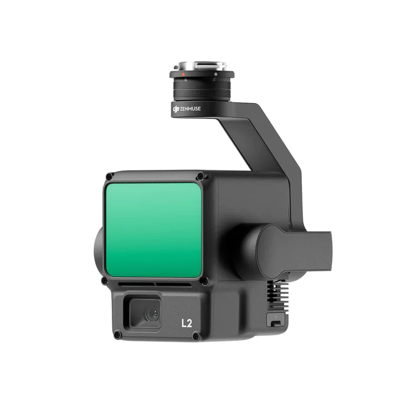 DJI Zenmuse L2LiDAR solution. Requires DJI RC Plus and a single downward gimbal mount.Explore Product ↗
 DJI Zenmuse H30TMulti-sensor camera with thermal imaging. Requires DJI RC Plus.Explore Product ↗
 DJI Zenmuse H30Multi-sensor observation camera. Requires DJI RC Plus.Explore Product ↗
Controller selection matters. L2, H30, H30T, S1 and V1 require DJI RC Plus on the M300 RTK. L2 is supported only on the single downward gimbal mount.
The other cards are drawn from Atay's M300 RTK compatible product list. Let us define the payload, mounting and firmware configuration for your project.
Other Compatible Payloads (14)
 Shenzhen Wayho SKY-W417 Airborne Hyperspectral SystemExplore Product ↗
 Shenzhen Wayho MAX-S810 Airborne Multispectral CameraExplore Product ↗
 CZI – ES638 Electronic Gas and Smoke LauncherExplore Product ↗
 CZI – FL60 Multicolor Warning LightExplore Product ↗
 CZI – IR10 Infrared SpotlightExplore Product ↗
 CZI – TH4 V2 Release DeviceExplore Product ↗
 CZI – DT1K Thermal SearchlightExplore Product ↗
 CZI – LP35 Searchlight and Broadcast SystemExplore Product ↗
 CZI – TK3 Power Supply System SeriesExplore Product ↗
 CZI – MP130 Pro Digital Audio Broadcasting SystemExplore Product ↗
 CZI – GL60 Plus Gimbal SearchlightExplore Product ↗
 CZI – C30N Dual-Sensor Night Vision Gimbal CameraExplore Product ↗
 Riebo D2M/DG3M Five-Lens Photogrammetric SensorExplore Product ↗
 TERSUS – MVP 400 UAV LiDAR Mapping SystemExplore Product ↗
Controllers and Platform Accessories
 DJI RC PlusRequires compatible M300 RTK firmware. This controller is required for L2, the H30 family, S1 and V1.Learn More ↗
 DJI CSM RadarOptional additional sensing accessory, subject to mounting and firmware compatibility.Learn More ↗
 TB65 Intelligent Flight BatteryCan be used as an alternative to TB60 with compatible firmware and charging equipment.Learn More ↗
 BS65 Intelligent Battery StationCharging station option compatible with TB60 and TB65 batteries.Learn More ↗
TB65 and BS65 are alternative equipment options. The main battery and station specifications on this page refer to the TB60 / BS60 configuration.[6]
Payloads and accessories are supplied separately depending on the selected package. Total payload, per-mount capacity and firmware requirements apply.
The Right Matrice 300 RTK for Your Project.
Let us configure the flight platform, payloads, controller and battery package for your operation.
Applications
Adapts to different field missions with suitable payloads and software.

Mapping and Surveying
Collect data for land surveying, 2D mapping and 3D modelling with a suitable camera or LiDAR payload.

Infrastructure and Facility Inspection
Inspect energy assets, industrial facilities and infrastructure; track changes with repeatable flights.
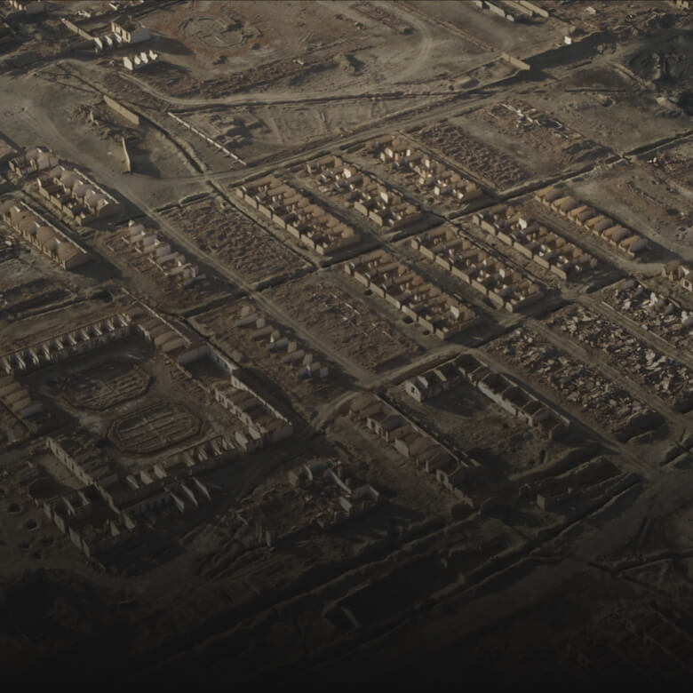
Search and Rescue and Disaster Management
Assess the site with suitable thermal and visual cameras and provide aerial information to response teams.