
SKYDIO AUTONOMOUS SYSTEMS
Skydio X10D
Mission-ready autonomy. Modular intelligence.
An advanced unmanned aerial vehicle (UAV) in the sky, managed by advanced artificial intelligence, equipped with state-of-the-art sensors. This smart drone is small yet capable of providing powerful and timely information. Thanks to dual-use innovation, these drones possess intelligent, survivable, and scalable features.

Flight Speed
Maximum flight speed listed for X10D.
Deployment
Fast startup for field operations.
Protection
Dust and water resistance.
Forward-looking cameras are designed to solve tasks.
The Skydio X10D features a modular design offering higher megapixel count and superior optical characteristics compared to other drones in its class. Equipped with high-resolution visual and radiometric thermal cameras, it provides the advantage of making decisions with precise and accurate information.
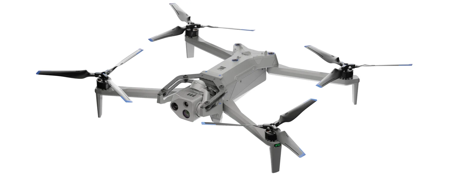

The correct sensors for your mission

VT300-Z
Sensor specifications
| Narrow camera | |
|---|---|
| - Equivalent focal length | 46 mm |
| - 64 MP | |
| - Aperture | f/1.8 |
| - Field of view | 50° |
| Telephoto camera | |
| - Equivalent focal length | 190 mm |
| - 48 MP | |
| - Aperture | f/2.2 |
| - Field of view | 13° |
| Radiometric thermal camera | |
| - Equivalent focal length | 60 mm |
| - Resolution | 640 x 512 pixels |
| - Field of view | 41° |
| - Sensitivity | <30 mK |

VT300-L
Sensor specifications
| Narrow camera | |
|---|---|
| - Equivalent focal length | 46 mm |
| - 64 MP resolution | |
| - Aperture | f/1.8 |
| - Field of view | 50° |
| 1" Wide camera | |
| - Equivalent focal length | 20 mm |
| - 50 MP resolution | |
| - Aperture | f/1.95 |
| - Field of view | 93° |
| Radiometric thermal camera | |
| - Equivalent focal length | 60 mm |
| - Resolution | 640 x 512 pixels |
| - Field of view | 41° |
| - Sensitivity | <30 mK |
| Flashlight | |
| - 22 lux at 3 meters | |
Mission-Relevant Detail.
The sensor packages of the Skydio X10D enhance your detection capabilities by capturing mission-relevant data in high resolution. This feature enables timely, relevant, and accurate decision-making in life-or-death situations.
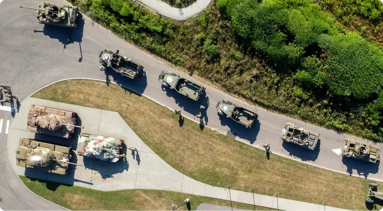
Place the entire operational area under the central coordination of mission control.
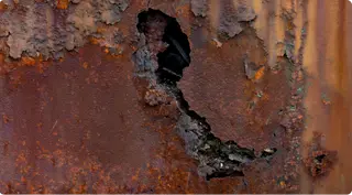
Achieve precision levels below millimeters in corrosion inspections.
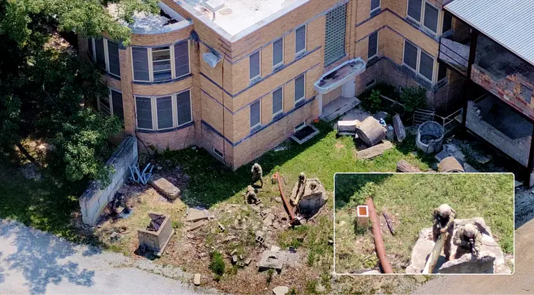
Observe individuals from a distance of 1 kilometer to detect indicators of hostile actions.
Work at night with unparalleled thermal imaging capabilities.
The Skydio X10D is the first small UAS (Unmanned Aerial System) to integrate the FLIR Boson+ sensor, providing the highest thermal imaging quality in its category. With a resolution of 640x512, the X10D offers enhanced sensitivity up to <=30 mK, promising more accurate radiometric readings anytime, anywhere.
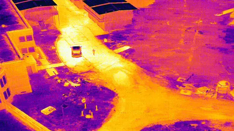
Detect temperature differences even on a hot day.
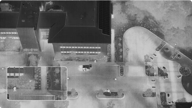
Detect a person on hot concrete even in completely dark conditions.
Add precise and timely details to every tactical decision.
Ready-made components did not provide the image quality your team desired. Therefore, we designed our own custom lenses. Equipped with unparalleled resolution and superior focus, our lenses are unmatched and cannot be found elsewhere.


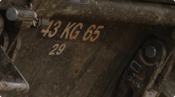
Image Processing
Achieve pixel-perfect images. Enhance white balance, reduce noise in photos, expand HDR capabilities, and more with sensors supported by the powerful Spectra 480 image signal processor.
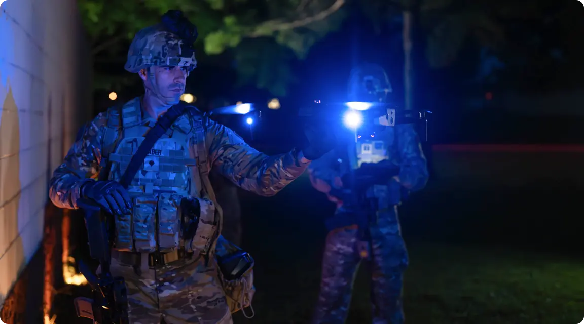
Zoom Performance
Achieve the highest quality zoom. Maintain superior image quality even in zoomed-in shots with a compact, smooth zoom system.
Low-Light Capture
Capture exceptional images in low light with lenses featuring custom f/1.8 and f/2.2 apertures, which gather 1.7-3.5 times more light than competitors, enabling faster exposure times.
Intelligence on Board.
Equipped with built-in artificial intelligence, the X10D boasts exceptional capabilities. It is a drone that reduces cognitive load for faster decision-making, understands its surroundings, automates data collection, and becomes smarter over time.
The X10D offers unparalleled computing power to support team operations and deliver real-time optimal decisions. Its specially designed six navigation lenses provide 360-degree visibility, eliminating blind spots and enabling fearless flight.

Fly with ease.
The Skydio X10D can confidently perform the most complex missions even in challenging environments. With advanced artificial intelligence-supported flight assistance and obstacle avoidance features, it reduces operators' cognitive load and significantly reduces the training time traditionally required for drones.

Automate basic tasks.
Utilize powerful built-in processing to enhance the speed and accuracy of basic tasks.
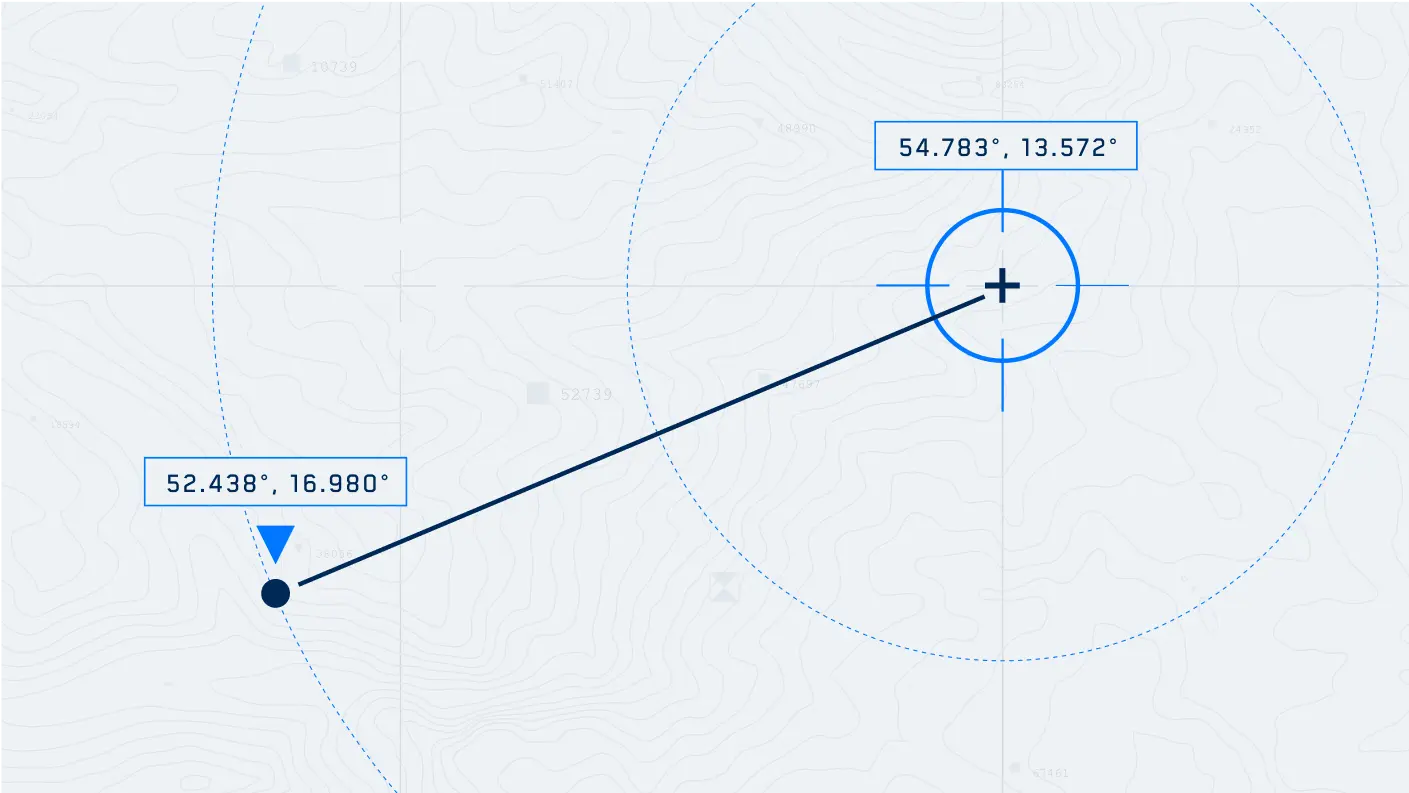
Identify points of interest with Plus Sign Coordinates.
Track targeted individuals with Subject Tracking.
Provide mobile surveillance with Scout.
Generate 2D maps and 3D models in real-time efficiently, without the need for additional systems.

Become smarter.
The Skydio X10D is designed as the only drone in its class with the most powerful built-in processing power, enhancing artificial intelligence data capture and synthesis capabilities over time.
And do it all in the dark.
For nighttime operations, predictive autonomous obstacle avoidance is crucial for mission success. A first in the industry: autonomy in darkness. Operate confidently 24/7 in NightSense mode for zero-light navigation, made possible only with the groundbreaking Skydio X10D.
The Skydio X10D utilizes visible or infrared illumination to avoid obstacles in darkness, understand its environment, and make accurate decisions at all times.
- IR Navigation Camera and Illuminator: X10D provides night vision using IR illumination.
- Visible Light Navigation Camera and Illuminator: X10D offers 360-degree visibility with visible illumination.

Control and Connectivity.
Fly worldwide as you wish.
Fly with the Skydio Controller.
Fly with a third-party controller.
Fly with Skydio Connect in various electromagnetic environments.
An operator experience shaped by thousands of flight hours.
Plan, execute, and review every type of mission in the redesigned Skydio Flight Deck application.
A completely redesigned professional-grade user interface. Navigate menus faster to save time and ensure quicker operations during critical missions.


Customize the interface to suit your needs.
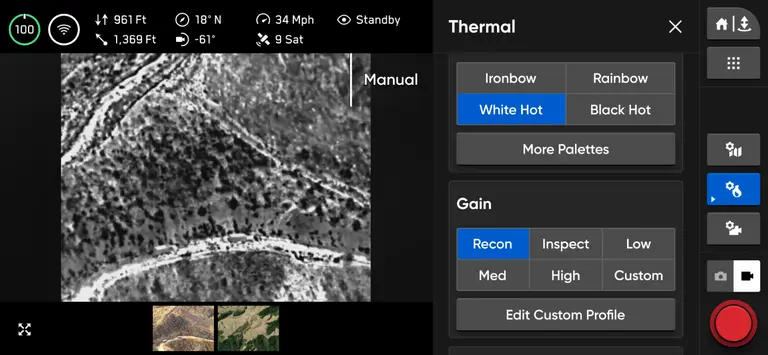
Always see what the drone sees.
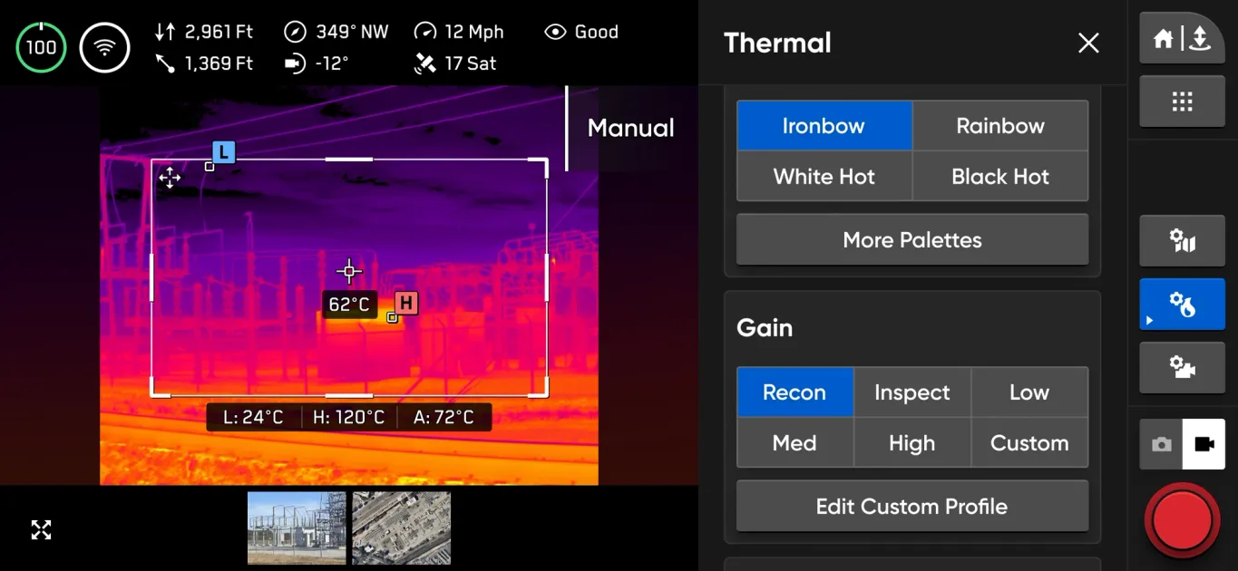
Quickly access critical data points.
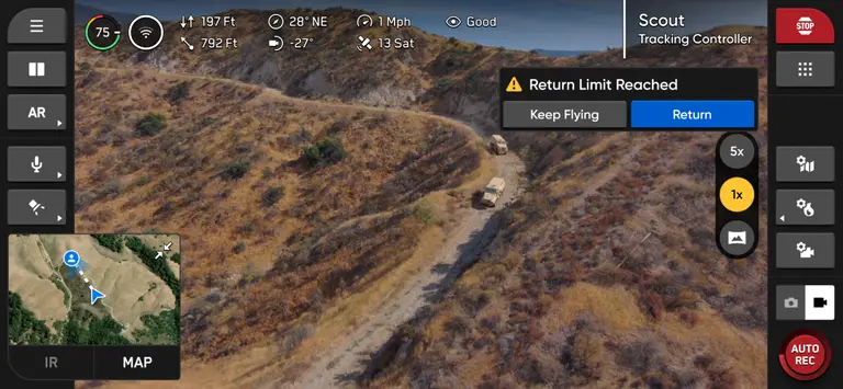
See when conditions change.
Integrated Applications

Crosshair Coordinates
It displays real-time ground-level coordinates using DTED maps in video location sharing.

Scout
Safely detect threats within your convoy.

Onboard Modeling
Create 2D/3D models in the field.
An open modular platform
The Skydio X10D is an open and modular platform. RAS-A compatibility and the open MAVLINK protocol enable integration of third-party and government-owned flight application software. Modular connector points allow operators to quickly swap additional payloads in the field.
Designed from the ground up to carry the performance of a heavy drone in a portable device that fits in a backpack, the X10D can fold down to a compact size compared to other drones with similar sensors. This capability enables truly distributed and dispersed operations.


TECHNICAL SPECIFICATIONS
Every Detail, in One Place.
Expand the sections below to explore Skydio X10D specifications and capabilities.
Drone
| Startup Time | Less than 40 seconds |
|---|---|
| Dimensions (unfolded, propellers included) | 31.1” x 25.6” x 5.7” |
| Dimensions (folded, without batteries) | 13.8” x 6.5” x 4.7” |
| Weight (including batteries) | |
| Connect SL | 2.11 kg / 4.65 lb |
| Connect MH | 2.14 kg / 4.72 lb |
| Maximum Takeoff Weight | 2.49 kg / 5.49 lb |
| Operating Frequency | |
| Connect SL | 2400-2483.5MHz, 5150-5850MHz |
| Connect MH | 1625-1725MHz, 1790-1850MHz, 2040-2110MHz, 2200-2300MHz, 2300-2390MHz, 2400-2500MHz |
| Transmitter Power (EIRP) | |
| Connect SL | 34.3dBm (2.4GHz), 33.7dBm (5GHz) |
| Connect MH | 38dBm |
| Hovering Accuracy (no wind or air disturbances) | |
| VIO | +/- 10cm |
| GNSS | +/- 1m |
| Maximum Angular Velocity | |
| Yaw | 100 degrees/second |
| Roll/Pitch | 225 degrees/second |
| Maximum Tilt Angle | 40 degrees |
| Maximum Ascent/Descent Speed | |
| Ascent | 6 m/s / 13.4 mph |
| Descent | 4 m/s / 9.0 mph |
| Maximum Vertical Non-Upward Descent Rate | 6 m/s / 13.4 mph |
| Maximum Horizontal Speed (at sea level) | 20 m/s / 45 mph |
| Maximum Horizontal Speed with Obstacle Avoidance | 16 m/s / 36 mph |
| Maximum Service Ceiling Above Sea Level (without other useful load) | 15,000 ft density altitude |
| Maximum Wind Resistance | 12.8 m/s / 28 mph or less |
| Maximum Spotlight Time | 35 minutes |
| Maximum Flight Time | * 40 minutes |
| Processors | NVIDIA Jetson Orin SoC, Qualcomm QRB5165 SoC |
| Ingress Protection Rating | IP55 |
| GNSS | GPS + Galileo + GLONASS + BeiDou |
| Geographic Boundary Restrictions | NO |
| Operating Temperature Range | -20°C to +45°C / -4°F to 113°F |
| Wireless Range (no interference, line of sight operation) | |
| Connect SL | 12 km / 7.5 miles |
| Connect MH | 10 km / 6.2 miles |
| Wireless Network (media offload) | None |
| Obstacle Avoidance Coverage | True 360° |
Controller
| Controller Dimensions | 10.5" x 5" x 3" |
|---|---|
| Screen | 6.6" Dynamic AMOLED touchscreen |
| 120Hz Adaptive Refresh Rate | |
| Resolution | 2340 x 1080 pixels |
| Brightness | 1750 nits (outdoor peak) |
| 392 ppi | |
| Dimensions | 10.5" x 5" x 3" |
| Weight | 1135 grams |
| Maximum Range | |
| Connect SL | 12 km / 7.5 miles |
| Connect MH | 10 km / 6.2 miles |
| Operating Frequencies | |
| Connect SL | 2400-2483.5MHz, 5150-5850MHz |
| Connect MH | 1625-1725MHz, 1790-1850MHz, 2040-2110MHz, 2200-2300MHz, 2300-2390MHz, 2400-2500MHz |
| Transmitter Power (EIRP) | |
| Connect SL | 34.7dBm (2.4GHz), 35.9dBm (5GHz) |
| Connect MH | 38dBm |
| Ingress Protection Rating | IP54 |
| Operation Time | Approx. 5 hours |
| Battery | 9600mAh |
| GNSS | GPS + Galileo + GLONASS + BeiDou |
| Geographic Boundary Restrictions | NO |
| Operating Temperature Range | -20°C to 45°C |
| Wired Outputs | HDMI and USB-C |
| Wireless Network | None |
| Security | |
| Listed on Blue UAS Cleared list | |
| NDAA compliant | |
| AES-256 encrypted data link | |
| Encrypted internal disk storage | |
| Password protected | |
| Trust anchor | |
| Secure boot | |
| Secure updates | |
VT300-Z and VT300-L Sensor Packages
| Angular Vibration Range | +/-0.01° |
|---|---|
| User-Controlled Range | +/-90° tilt |
| Mechanical Range | +/-140° tilt, +/-90° pan, +75° to -230° roll |
Telephoto Camera
| Sensor | 1/2" 48MP CMOS |
|---|---|
| Cross Field of View | 13° |
| Focal Length | 35 mm (equivalent to 190 mm) |
| Aperture | f/2.2 |
| Focus | Hybrid PDAF, 5 m to ∞ |
| Exposure Compensation | +-3 |
| Electronic Shutter Speed | 1/30 to 1/8000 |
| ISO Range | 100 - 16000 |
| Maximum Video Resolution | 3840x2880 |
| Maximum Photo Size | 8000x6000 |
Wide Camera
| Sensor | 1" 50.3 MP CMOS |
|---|---|
| Cross Field of View | 93° |
| Focal Length | 8 mm (equivalent to 20 mm) |
| Aperture | f/1.95 |
| Focus | 100% pixel focus, 1 m to ∞ |
| Exposure Compensation | +-3 |
| Electronic Shutter Speed | 1/30 to 1/8000 |
| ISO Range | 100 - 16000 |
| Maximum Video Resolution | 3840x2880 |
| Maximum Photo Size | 8192x6144 |
Narrow Camera
| Sensor | 1/1.7" 64 MP CMOS |
|---|---|
| Cross Field of View | 50° |
| Focal Length | 10 mm (equivalent to 46 mm) |
| Aperture | f/1.8 |
| Focus | Hybrid PDAF, 1 m to ∞ |
| Exposure Compensation | +-3 |
| Electronic Shutter Speed | 1/30 to 1/8000 |
| ISO Range | 100 - 16000 |
| Maximum Video Resolution | 3840x2880 |
| Maximum Photo Size | 9248x6944 |
Thermal Camera
| Thermal Imager | Flir Boson+ Uncooled VOx Microbolometer |
|---|---|
| Cross Field of View | 41° |
| Focal Length | 13.6 mm (equivalent to 60 mm) |
| Aperture | f/1.0 |
| Focus | 5 m to ∞ |
| Thermal Sensitivity | <30mK NEDT |
| Infrared Temperature Measurement Accuracy | +- 5°C or >5% |
| Image Processing | Adreno 650 GPU accelerated ISP pipeline |
| Maximum Video Resolution | 640x512 |
| Photo Size | 640x512 |
| Photo Format | JPEG, RJPEG |
| Pixel Pitch | 12 µm |
| Temperature Measurement Methods | Spot Meter, Area Measurement |
| Temperature Measurement Range | -40°C to 150°C (-40°C to 350°C in low gain mode) |
| Palette | White hot, black hot, iron bow, rainbow |
Sensor Package Light
| Lighting | 1000 lumens |
|---|
Vision Systems / Navigation Cameras
| Configuration | Top and bottom trinocular configuration with 6x cameras |
|---|---|
| Sensor | Samsung 1/2.8" 32MP color CMOS |
| Light Sensitivity | Visible light |
| Aperture | f/1.8 |
| Field of View | 200° |
| Obstacle Detection Range | 20 meters |
| Environmental Coverage | True 360° |
Flight Battery
| Capacity | 8419 mAh |
|---|---|
| Voltage | 18.55V |
| Battery Type | Rechargeable Lithium Ion Polymer |
| Energy | 156.17 Wh |
| Net Weight | 1.56 lb +/- 0.003 lb |
| Operating Temperature Range | -20°C to 60°C |
| Storage Temperature Range | -20°C to +45°C (for storage less than 3 months) |
| Charging Temperature Range | 5°C to 45°C |
| Chemical System | Lithium Ion Polymer |
Skydio Link
| Operating Frequencies | |
|---|---|
| Connect SL | 2400-2483.5 MHz, 5150-5850 MHz |
| Connect MH | 1625-1725 MHz, 1790-1850 MHz, 2040-2110 MHz, 2200-2300 MHz, 2300-2390 MHz, 2400-2500 MHz |
| Transmitter Power (EIRP) | |
| Connect MH | 38 dBmi |
| Antenna Configuration | |
| Connect SL | 2Tx, 4Rx |
| Connect MH | 2x2 |
System Security
| Wireless Encryption | |
|---|---|
| Connect SL | AES-256 |
| Connect MH | AES-256 |
| Blue UAS List | |
| Listed on the Blue UAS List and approved by the Department of Defense | |
| NDAA Compliance | |
| NDAA Compliant | |
| Root of Trust | |
| HSM-protected keys | |
| System Integrity | |
| Secure Boot | |
| Secure Updates | |
| Encrypted with AES-256, signed, and verified | |
| Internal Disk Storage | |
| Encrypted | |
| SD Cards | |
| Encrypted | |
| Pairing | |
| Secure wired pairing | |
Dual Charging Device
| Dimensions | 180x75x48 mm |
|---|---|
| Weight (Without Battery) | 0.73 lbs |
| Charging Time 230W | 1 hour (0-100%) |
| 35 minutes (20-90%) | |
| Charging Time 100W | 1 hour 45 minutes (0-100%) |
| 1 hour 10 minutes (20-90%) | |
| Weather Resistance | No ingress protection |
The Right Skydio X10D Setup for Your Project.
Talk to the Atay team about your application, configuration and workflow requirements.
EXPLORE SKYDIO


