
DJI ENTERPRISE
Mavic 3M
See More. Work Smarter.
DJI Mavic 3 Multispectral combines an RGB camera with multispectral cameras to scan and analyse crop growth. Agricultural production management requires precision and data. Mavic 3M provides both.

Multispectral camera
Green, red, red edge and near infrared.
RGB camera
4/3 CMOS sensor and mechanical shutter.
Maximum flight time
Efficient flight for extended field missions. [1]
Coverage per flight
Depends on mission and test conditions. [3]
Precise positioning
Microsecond-level time synchronisation.
Compact and portable
Weight including propellers and RTK module.
Multispectral + RGB Imaging System
One 20 MP RGB camera and four 5 MP multispectral cameras form a highly integrated imaging system. It supports applications such as high-precision aerial surveying, natural resource surveys and crop growth monitoring.

20 MP RGB
4/3 CMOS sensor, 24 mm equivalent focal length and JPEG / DNG (RAW) recording.
1/2000 s
Maximum mechanical shutter speed of the RGB camera; helps reduce motion blur during mapping flights.
0.7 s RGB Capture
Minimum interval for JPEG capture with the RGB camera only. The multispectral TIFF capture interval starts at 2 seconds.
Compact Airframe. Versatile Data.
Take a closer look at the foldable, easy-to-store Mavic 3M and its multispectral workflow.
Sunlight Sensor
The built-in sunlight sensor captures solar irradiance and records it in the image file. This data enables light compensation during 2D reconstruction, supporting consistent NDVI results and data collected at different times.
Accurate Images, Every Pixel
The RTK module supports centimetre-level positioning. Flight control, cameras and the RTK module synchronise within microseconds, matching each camera's imaging centre to an accurate position.
Precise Aerial Surveying
Under suitable RTK and mission conditions, high-precision aerial surveys can be conducted without ground control points. RTK positioning accuracy and final map accuracy are different metrics and must be assessed separately.
Efficient Aerial Surveying
Up to 43 minutes of flight time and coverage of up to 200 hectares per flight under suitable mission conditions.[1][3]
100 W Charging Hub
Sequential charging of three batteries simplifies preparation between field missions.
88 W Direct Charging
Supports fast charging through the drone with a compatible adapter.
Stable Image Transmission
The O3 transmission system's 2T4R antenna configuration delivers 1080p / 30 fps live video to the controller.
Maximum communication distance is 15 km for FCC and 8 km for CE / SRRC / MIC.[2]
Omnidirectional Obstacle Sensing and Terrain-Following Aerial Surveys
Multiple wide-angle sensors help detect obstacles in different directions. Terrain following makes aerial survey planning easier on sloping sites.
Vision system performance depends on lighting and surface conditions. Observe the operating ranges stated in the specifications.
From Data to Agricultural Decisions
Turn RGB and multispectral data into useful outputs for field management with suitable analysis software.
Vegetation Indices
Assess spatial variations in plant development using NDVI, GNDVI and NDRE imagery.
Variable-Rate Application
Supply compatible agricultural application equipment with prescription maps prepared from multispectral data.
Orchard Mapping
Create orchard maps and agricultural flight routes using DJI Terra or supported DJI SmartFarm Web workflows.
Software and Integration
DJI Pilot 2
Access flight and camera controls, mapping routes and image data through the controller.
Cloud API
Transfer imagery and mission information to compatible third-party cloud platforms through DJI Pilot 2.
Mobile SDK 5
Develop custom mobile applications for field monitoring and surveying missions.
DJI SmartFarm Web and mobile connectivity services vary by region. Software licences depend on the selected package.
Agricultural Solution Package
Explore Atay's solution combining the DJI Mavic 3M Multispectral Drone with PIX4Dfields.
Consider the aircraft and software together for drone-based agricultural mapping and multispectral analysis.

Package Contents
Standard and Additional-Battery Packages
Standard Package
- DJI Mavic 3 Multispectral UAV.
- 1 battery supplied with the product.
Additional-Battery Package
- DJI Mavic 3 Multispectral UAV with 1 included battery.
- DJI Mavic 3 Enterprise Part5 Battery Kit: 3 additional batteries.
The two package options shown are from the Atay product page. Controller, charging equipment and other delivery details are confirmed in the quotation.
Technical Specifications
All the details, together.
Drone
Drone
| Net Weight | 951 g (with propellers and RTK module) |
|---|---|
| Maximum Takeoff Weight | 1,050 g |
| Dimensions | Folded, without propellers: 223 × 96.3 × 122.2 mm Unfolded, without propellers: 347.5 × 283 × 139.6 mm (L × W × H) |
| Diagonal Length | 380.1 mm |
| Maximum Ascent Speed | 6 m/s (Normal Mode) 8 m/s (Sport Mode) |
| Maximum Descent Speed | 6 m/s |
| Maximum Flight Speed | Normal Mode: 15 m/s Sport Mode: forward 21 m/s, sideways 20 m/s, backward 19 m/s Maximum speed is limited to 19 m/s in the EU. |
| Maximum Wind Resistance | 12 m/s |
| Maximum Takeoff Altitude | 6000 m (without a payload) |
| Maximum Flight Time | 43 minutes in a windless test environment. [1] |
| Maximum Hovering Time | 37 minutes in a windless test environment. [1] |
| Maximum Flight Distance | 32 km; total flight distance, not communication range. [1] |
| GNSS | GPS + Galileo + BeiDou + GLONASS GLONASS is supported when the RTK module is enabled. |
| Operating Temperature | -10 °C to 40 °C |
| Maximum Pitch Angle | Normal Mode: 30° Sport Mode: 35° |
| Maximum Angular Velocity | 200°/s |
| Hovering Accuracy | Vertical: ±0.1 m (vision system); ±0.5 m (GNSS); ±0.1 m (RTK) Horizontal: ±0.3 m (vision system); ±0.5 m (high-precision positioning); ±0.1 m (RTK) |
| Motor / Propeller | 2008 motor / 9453F Enterprise propeller |
| Internal Storage | None; images are saved to microSD. |
| Sunlight Sensor | Integrated into the airframe; solar irradiance data is recorded in the image file. |
| Supported Memory Card | microSD with a speed class of V30 or higher; select compatible models from the manufacturer's recommended card list. |
RGB Camera
RGB Camera
| Image Sensor | 4/3 CMOS Effective pixels: 20 MP |
|---|---|
| Lens | FOV: 84° Equivalent focal length: 24 mm Aperture: f/2.8 – f/11 Focus: 1 m–∞ |
| ISO Range | 100 – 6400 |
| Shutter Speed | Electronic: 8 – 1/8000 s Mechanical: 8 – 1/2000 s |
| Maximum Image Size | 5280 × 3956 |
| Photo Shooting Modes | Single shot: 20 MP Timed: 20 MP JPEG: 0.7 / 1 / 2 / 3 / 5 / 7 / 10 / 15 / 20 / 30 / 60 s JPEG + RAW: 3 / 5 / 7 / 10 / 15 / 20 / 30 / 60 s Panorama: 20 MP |
| Video Resolution | H.264 4K: 3840 × 2160 @ 30 fps FHD: 1920 × 1080 @ 30 fps |
| Maximum Video Bitrate | 4K: 130 Mbps FHD: 70 Mbps |
| File System | exFAT |
| Image Format | JPEG / DNG (RAW) |
| Video Format | MP4 (MPEG-4 AVC / H.264) |
Multispectral Camera
Multispectral Camera
| Image Sensor | 1/2.8-inch CMOS Effective pixels: 5 MP |
|---|---|
| Lens | FOV: 73.91° Equivalent focal length: 25 mm Aperture: f/2.0 Focus: fixed focus |
| Camera Bands | Green: 560 ± 16 nm Red: 650 ± 16 nm Red Edge: 730 ± 16 nm Near Infrared: 860 ± 26 nm |
| Gain Range | 1x – 32x |
| Shutter Speed | Electronic: 1/30 – 1/12800 s |
| Maximum Image Size | 2592 × 1944 |
| Image Format | TIFF |
| Video Format | MP4 (MPEG-4 AVC / H.264) |
| Photo Shooting Modes | Single shot: 5 MP Timed: 5 MP TIFF: 2 / 3 / 5 / 7 / 10 / 15 / 20 / 30 / 60 s |
| Video Resolution | H.264 FHD: 1920 × 1080 @ 30 fps Video content: NDVI / GNDVI / NDRE |
| Maximum Video Bitrate | Stream: 60 Mbps |
Gimbal and Sensing
Gimbal
| Stabilization | 3 axes: tilt, roll and pan |
|---|---|
| Mechanical Range | Tilt: −135° to +45° Roll: −45° to +45° Pan: −27° to +27° |
| Controllable Range | Tilt: −90° to +35° Pan cannot be controlled independently. |
| Maximum Tilt Control Speed | 100°/s |
| Angular Vibration Range | ±0.007° |
Sensing System
| System Type | Omnidirectional binocular vision system and an infrared sensor on the underside of the airframe. |
|---|---|
| Forward | Measurement range: 0.5 – 20 m Detection range: 0.5 – 200 m Effective avoidance speed: ≤15 m/s Field of view: horizontal 90°, vertical 103° |
| Backward | Measurement range: 0.5 – 16 m Effective avoidance speed: ≤12 m/s Field of view: horizontal 90°, vertical 103° |
| Lateral | Measurement range: 0.5 – 25 m Effective avoidance speed: ≤15 m/s Field of view: horizontal 90°, vertical 85° |
| Upward | Measurement range: 0.2 – 10 m Effective avoidance speed: ≤6 m/s Field of view: front/rear 100°, left/right 90° |
| Downward | Measurement range: 0.3 – 18 m Effective avoidance speed: ≤6 m/s Field of view: front/rear 130°, left/right 160° |
| Operating Environment | Clearly textured surfaces and lighting >15 lux. Downward sensing requires surfaces with diffuse reflectivity >20% and lighting >15 lux. |
Video Transmission and Controller
Video Transmission
| Video Transmission System | DJI O3 Enterprise Transmission |
|---|---|
| Live View Quality | Remote controller: 1080p / 30 fps |
| Operating Band | 2.400 – 2.4835 GHz 5.725 – 5.850 GHz |
| Maximum Signal Distance | Without obstacles or interference: FCC: 15 km CE / SRRC / MIC: 8 km [2] |
| Maximum Transmission Distance | Strong interference: 1.5 – 3 km Moderate interference: 3 – 9 km (FCC), 3 – 6 km (CE/SRRC/MIC) Low interference: 9 – 15 km (FCC), 6 – 8 km (CE/SRRC/MIC) |
| Maximum Download Speed | 15 MB/s |
| Latency | Approx. 200 ms |
| Antennas | 4 antennas, 2 transmitters and 4 receivers |
| Transmitter Power | 2.4 GHz: <33 dBm (FCC), <20 dBm (CE/SRRC/MIC) 5.8 GHz: <33 dBm (FCC), <30 dBm (SRRC), <14 dBm (CE) |
| Other | Supports the optional DJI Cellular module. Do not install the module on the drone during multispectral data capture, as it may obstruct the sunlight sensor. Regional service conditions apply. [5] |
DJI RC Pro Enterprise
| Model | DJI RC Pro Enterprise |
|---|---|
| Display | 5.5-inch; 1920 × 1080 resolution; 60 fps |
| Screen Brightness | 1000 nit |
| Touch Control | 10-point multi-touch |
| Internal Battery | Li-ion; 5000 mAh @ 7.2 V |
| Rated Power | 12 W |
| Operating Time | Approximately 3 hours; depends on operating conditions. |
| Charging Time | Approximately 1 hour 30 minutes: with a 100 W DJI adapter charging only the controller or a 15 V USB charger. Approximately 2 hours: with a 12 V USB charger. Approximately 2 hours 50 minutes: with a 100 W adapter charging the drone and controller together. [4] |
| Storage | 64 GB internal storage; expandable with microSD. |
| Video Output | Mini-HDMI |
| Wi-Fi | 802.11 a/b/g/n/ac/ax; 2 × 2 MIMO 2.400–2.4835 / 5.150–5.250 / 5.725–5.850 GHz [2] |
| Bluetooth | Bluetooth 5.1; 2.400–2.4835 GHz |
| Operating Temperature | −10 °C to +40 °C |
| Microphone | Built-in microphone |
Battery and Charging
Battery
| Capacity | 5000 mAh |
|---|---|
| Nominal Voltage | 15.4 V |
| Maximum Charging Voltage | 17.6 V |
| Battery Type | LiPo 4S |
| Chemistry | Lithium Cobalt |
| Energy | 77 Wh |
| Weight | 335.5 g |
| Charging Temperature | 5° – 40°C |
Power Adapter and Charging Hub
| Adapter Input | 100–240 V AC; 50–60 Hz; 2.5 A |
|---|---|
| Adapter Output Power | Maximum total 100 W. When both ports are used, power is distributed according to demand; maximum 82 W per port, maximum 100 W total. |
| Charging on the Drone | Maximum 88 W fast charging |
| Charging Hub Input | USB-C: 5–20 V, 5 A |
| Charging Hub Battery Output | 12–17.6 V, 8 A |
| Charging Hub Rated Power | 100 W |
| Charging Method | Three batteries charge sequentially. |
| Charging Temperature Range | +5 °C to +40 °C |
RTK Module
RTK Module
| Dimensions | 50.2 × 40.2 × 66.2 mm |
|---|---|
| Weight | 24 ± 2 g |
| Interface | USB-C |
| Power | Approx. 1.2 W |
| RTK Positioning Accuracy | RTK Fixed: Horizontal: 1 cm + 1 ppm Vertical: 1.5 cm + 1 ppm |
- The 43-minute flight time was measured at sea level in windless conditions at a constant 36 km/h; the 32 km total flight distance was measured at 57.6 km/h. The 37-minute hovering time is a separate test value. Actual results vary with battery, environmental and flight conditions.
- 15 km FCC and 8 km CE / SRRC / MIC are one-way communication distances measured in unobstructed, interference-free conditions; they are not round-trip flight ranges. Frequency availability and performance depend on regional conditions.
- 200-hectare coverage was measured in sunny, windless conditions at 15 m/s, a flight height of 217 m, GSD of 5.73 cm for RGB and 10 cm for multispectral imagery, 70% forward overlap and 60% side overlap. Coverage and resulting map accuracy depend on mission conditions.
- Charging times and power values may vary with the adapter, devices charged simultaneously and battery temperature.
- The DJI Cellular module and DJI SmartFarm Web service are unavailable in some countries. Do not mount the DJI Cellular module on the drone during multispectral imaging, as it may obstruct the sunlight sensor.
Compatible Equipment and Accessories
Positioning, control and connectivity solutions for your requirements.
 DJI RC Pro EnterpriseField control with 1000-nit brightness and a 5.5-inch display.Learn More ↗
 D-RTK 2 Mobile StationLocal correction data in a compatible RTK workflow.Learn More ↗
 DJI Cellular ModuleMobile connectivity in supported regions. Not used on the drone during multispectral capture.Learn More ↗
The RTK module is part of the Mavic 3M system. D-RTK 2 and the Cellular module are optional; discuss package contents and regional service support with Atay. [5]
Mavic 3M for Your Project.
Contact the Atay Mühendislik team for detailed information about Mavic 3M and compatible equipment.
Applications
Multispectral data for agriculture, crop development and natural resource surveys.
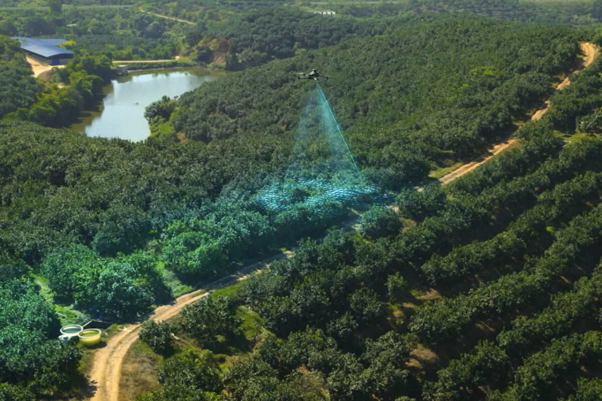
Orchard Mapping
Capture imagery over sloping orchards with terrain following; prepare maps and agricultural operation routes.
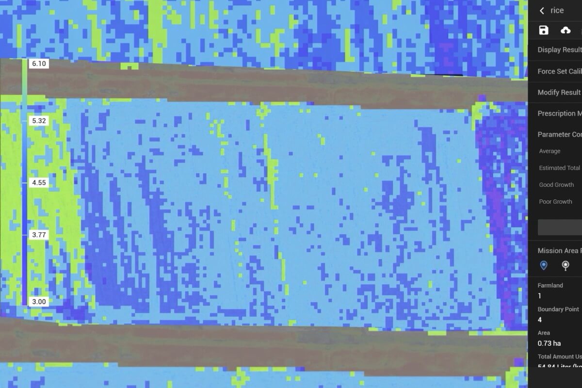
Variable-Rate Application
Examine variations in plant development on index maps and identify application zones.
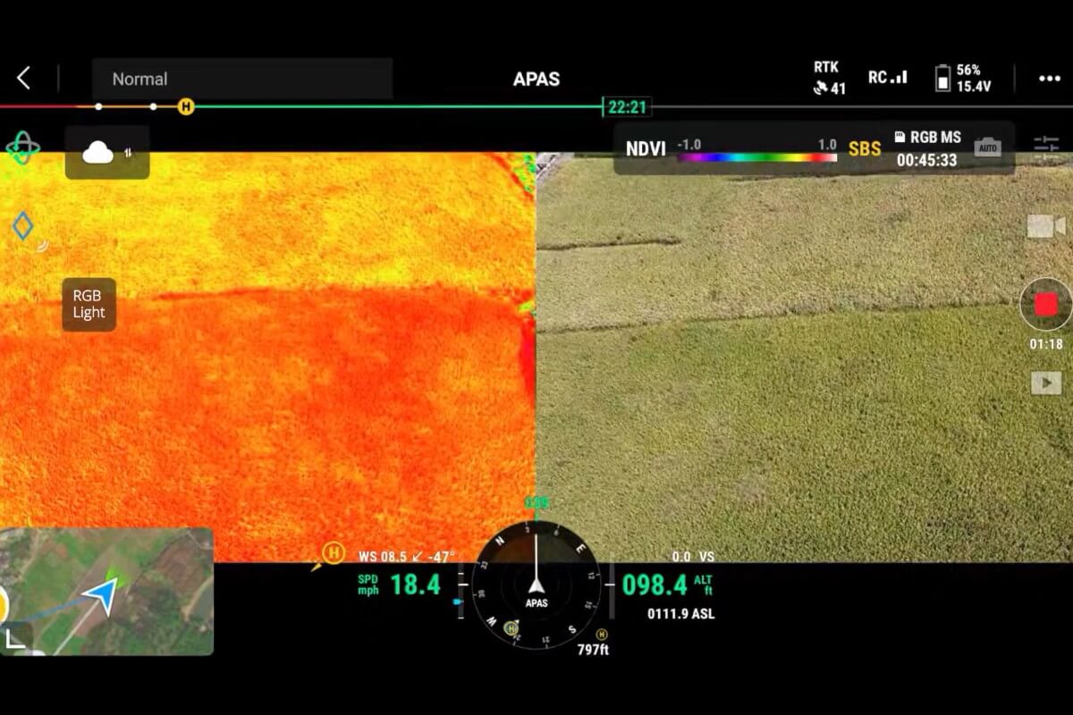
Intelligent Field Monitoring
Monitor crop development with repeated surveys and collect comparable data for natural resource and environmental research.